GreeneScene Magazine
  • ArticlesNEW
  • Contests
    • GreeneScene Reader Survey
    • Fair Food Favorites
    • Person Place or Thing
    • Where is This?
  • Podcast
  • Submit
    • Submit a GreeneScene
    • GreeneScene of the Past
    • Community Events
    • Classified Ads
    • News Releases
  • Events
  • More
    • Contact
    • What’s the GreeneScene?
    • Print Archive
    • Ad Rates
    • Circulation
    • Subscriptions
    • Our Parent Company
No Result
View All Result
GreeneScene Magazine
No Result
View All Result
Home Local History

The Rest is History

Farley Toothman by Farley Toothman
June 10, 2026
in Local History
0
Illustrated map of Greene County's Frontier Forts Trail showing four historic fort sites, landmarks, routes, and driving information.
Share on FacebookShare on Twitter

Two hundred fifty years ago, Greene County wasn’t the southwest corner of Pennsylvania … it was the wild west frontier of a developing nation.

Pennsylvania was created in 1681 by a land-grant from King Charles II, but Greene County’s earth wasn’t part of the deal. This land was designated the “western frontier” and/or “Indian Reserve.”

But as the nation moved west, borders overlapped and boundary disputes were many among what we now recognize to be Pennsylvania, Maryland, Virginia and West Virginia. The skirmishes were mostly settled by the mapping of the Mason-Dixon Line, and therefore, various counties sprung up.

Westmoreland County was divided out of Bedford County in 1773. Five years later Washington County was divided from Westmoreland County in 1781. Fayette County was created in 1783. And in 1796, Greene County was carved out of Washington County. That same year 201 building lots were first offered for sale in Waynesburg as the seat of government. It wasn’t incorporated until 1816.

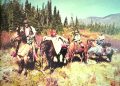
Turning a Native American frontier into a community of European settlements wasn’t easy, and we still honor it 250 years later. The Revolutionary War kicked off an eight-year struggle with England for independence. We fought the natives; we fought the King; and then we fought our neighbors and neighboring states.

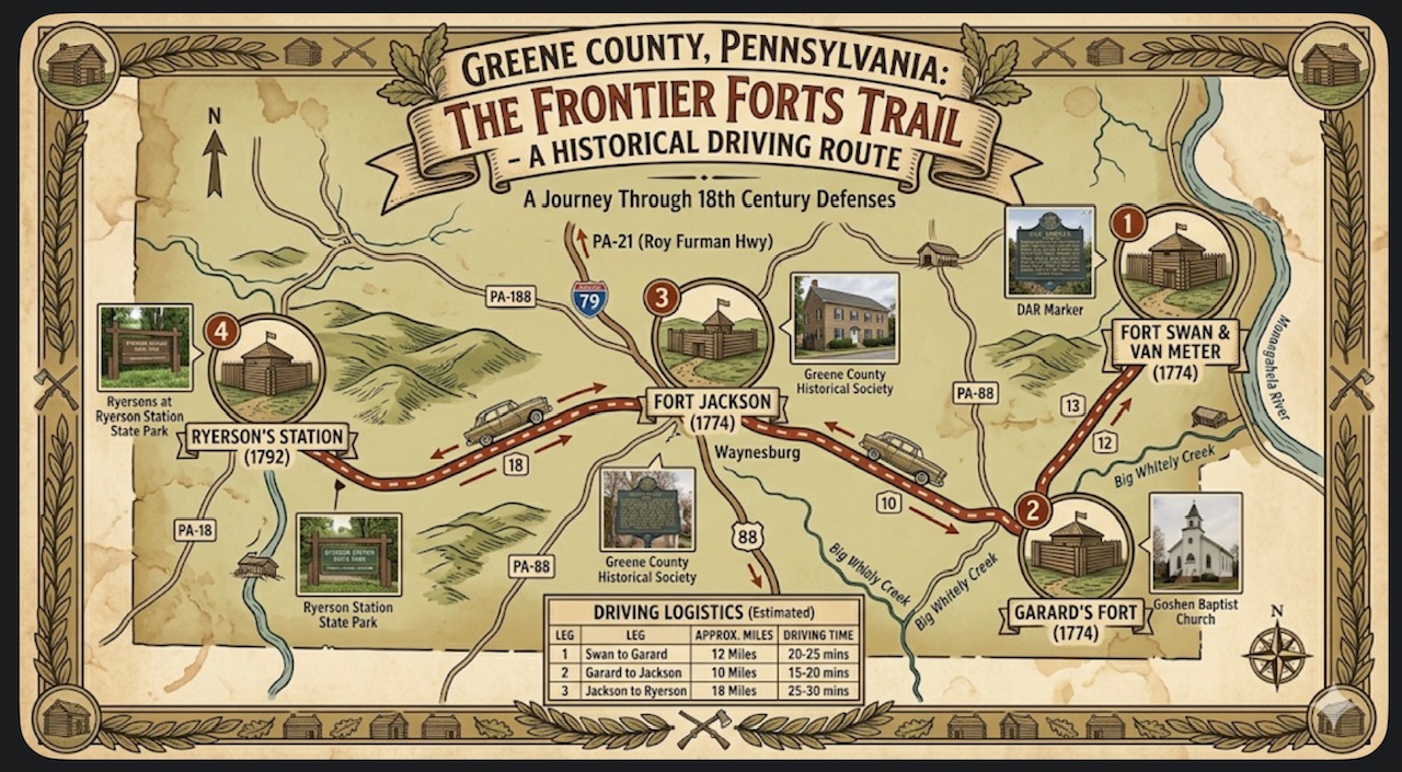
Early settlers built four forts locally as refuge from native raiding parties: Jackson’s Fort in Waynesburg, Garard’s Fort in Greene Township, Fort Swan & VanMeter in Cumberland Township, and later Ryerson’s Fort in Richhill Township, along the major trading route between the Ohio and Monongahela Rivers.

The Jackson’s Fort, built in 1774 started as a single cabin on the property of a man named Jackson. It eventually expanded into cabins connected by 10-to-12-foot high palisades. The fort had only one entrance. Jackson’s Fort was a critical defensive post during the Revolutionary War, and it was supplied from Fort Pitt. Today, there is but a historical marker along the sidewalk on east Greene Street.

Garard’s Fort was located on the left bank of Whiteley Creek in Greene Township. It was an essential place of safety in the fertile but exposed valleys. It began as a station for a small detachment of Virginia militia but is memorable for the nearby tragic Corbly Massacre in May of 1782. Reverend John Corbly was walking to church with his family when they were ambushed by natives. His wife and three of his children were brutally killed and scalped, and two other daughters severely wounded.

Fort Swan and Van Meter is named for early pioneers John Swan and Jesse Vanmeter who, along with Thomas Hughes, had pooled their resources. It was located near the border of Cumberland Township and Carmichaels on John Swan’s farm. It was a rallying point for the pioneers who settled the Pumpkin Valley area, near the Monongahela River.

Ryerson’s Fort was built by the authorities of Virginia at the confluence of the north and south forks of the Dunkard branch of Wheeling Creek. It was an important strategic defense point because it sat directly on the great Native war path between the Ohio and Monongahela Rivers. Captain James Seals (who owned the land that is now Waynesburg Borough) was dispatched to defend it against hostile Natives. While these forts were being used to defend against the Natives, the Revolutionary War had begun in Massachusetts.

The Natives controlling this area were known as “The Iroquois Confederacy of Six Tribal Nations” consisting of the Mohawks, Oneidas, Onondagas, Cayugas, Senecas, and Tuscaroras. However, the Shawnee Nation possessed historical hunting rights and refused to recognize the 1768 treaty whereby the Iroquois sold the land to the British. The Delaware and Mingo tribes were also prominent forces, frequently allying with the Shawnee to launch raids against the frontier settlements and forts. These overlapping claims fueled brutal frontier-style warfare.

When the Revolutionary War was in full swing, Colonel John Minor was the key militia officer from the Mapletown area. He is considered the “Father of Greene County” because he sponsored the bill that made the division from Washington County a reality.

There is so much more, but the rest is History.

Donation

Buy author a coffee

Donate
Tags: Greene County historyPennsylvania FrontierRevolutionary War
Farley Toothman

Farley Toothman

Related Posts

The cover of the 1976 to 1977 Backroads publication features a Greene County map surrounding a black and white photo of sheep grazing in a rural field.
Local History

Backroads Redux.

by Bret Moore
June 26, 2026
A split image shows a rural farm above an underground coal mine tunnel with a miner, representing the region's agricultural and mining heritage.
Local History

Plows and Pickaxes: Greene County’s Dual Legacy

by GreeneScene Magazine
June 26, 2026
A vintage photo shows young parade participants carrying an American flag and a banner as they march down a town street lined with spectators and classic cars.
Local History

Harvest, Horses, and Commerce: The Economic Legacy of County Fairs

by GreeneScene Magazine
June 26, 2026
Next Post
The Appalachian Fly Fishing Festival logo features a fishing fly, mountain outline, and fly rod with reel.

The Appalachian Fly Fishing Festival in Thomas, WV

Leave a Reply Cancel reply

Your email address will not be published. Required fields are marked *

I agree to the Terms & Conditions and Privacy Policy.

The GreeneScene Podcast The GreeneScene Podcast The GreeneScene Podcast

Recommended

A smiling woman with long dark hair poses for a professional portrait against a black and gold background.

Golden Arches

May 22, 2026
Summer Time: Hunting and Cooking GROUNDHOG?

Summer Time: Hunting and Cooking GROUNDHOG?

March 5, 2026
A woman in western attire stands beside a horse in a sunny outdoor pasture setting.

Bridled Faith: Learning Leadership and Love at His Barn

May 22, 2026
Grunge American flag pattern with stars and stripes symbolizing 250th anniversary of US Independence Day celebration in 2026.

America Celebrates its Semi-quincentennial or Semiquincentennial?

May 27, 2026
A scenic view of Mon View Park in Greensboro features playgrounds, open grassy areas, large trees, and the Mon View Roller Rink and Community Center sign.

Mon View Park: A Hidden Gem

June 30, 2026
A rustic display inside a country gift shop features floral arrangements, ceramic frogs, decorative signs, and handcrafted home decor.

Summer in the Country

June 30, 2026
A train themed parade vehicle travels through the Pennsylvania Bituminous King Coal Show parade as spectators watch from the roadside.

The King Coal Show: Honoring Our Past, Celebrating Our Community

June 30, 2026
Five crowned fair royalty winners wearing sashes pose with bouquets in front of a pink and floral celebration backdrop.

Greene County Fair Queen Program Celebrates 40 years

June 30, 2026
Wilson Accounting Group Wilson Accounting Group Wilson Accounting Group

Archives

  • 2026
  • 2025
  • 2024
  • 2023
  • 2022
  • 2021
  • 2020
  • 2019
  • 2018

Recent Posts

  • Mon View Park: A Hidden Gem
  • Summer in the Country
  • The King Coal Show: Honoring Our Past, Celebrating Our Community

Categories

  • Arts & Entertainment
  • Business
  • Business Spotlight
  • Community
  • Cool at School
  • Crowded Kitchen
  • Education
  • Events
  • Featured
  • Food
  • Good News in Greene
  • Government
  • Health & Wellness
  • Hometown Heritage
  • Leisure
  • Local History
  • Local People
  • Opinion
  • Outdoors
  • Pets
  • Piece of My Mind
  • Public Service
  • Religion
  • Scene and Heard
  • Seasonal
  • Special Interest
  • Sports
  • Supernatural
  • Towne Square
  • Uncategorized

© 2025 GreeneScene Magazine - A Direct Results Company

No Result
View All Result
  • Articles
  • Contests
    • GreeneScene Reader Survey
    • Fair Food Favorites
    • Person Place or Thing
    • Where is This?
  • Podcast
  • Submit
    • Submit a GreeneScene
    • GreeneScene of the Past
    • Community Events
    • Classified Ads
    • News Releases
  • Events
  • More
    • Contact
    • What’s the GreeneScene?
    • Print Archive
    • Ad Rates
    • Circulation
    • Subscriptions
    • Our Parent Company

© 2025 GreeneScene Magazine - A Direct Results Company

This website uses cookies. By continuing to use this website you are giving consent to cookies being used. Visit our Privacy and Cookie Policy.