With Memorial Day weekend coming up how about lunch in Hundred, WV, then a back roads return into Pennsylvania to Hero and Jollytown for a visit with Private Jesse Taylor, Greene County’s first casualty of the Civil War?
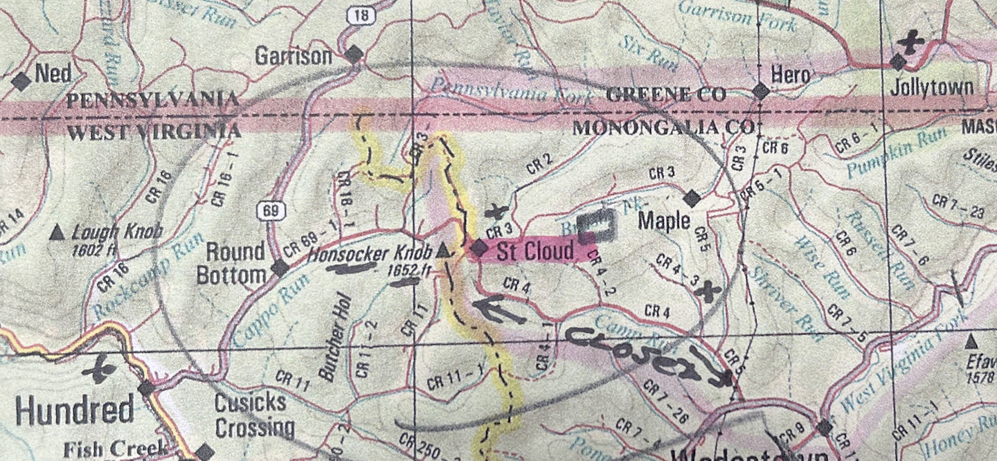
The problem with consulting the Official Map of Greene County that every back roads warrior should have tucked in the glove compartment, is that all roads end at the county line. And for those who use Google maps, some of the best adventures are to be had where the Internet can’t be found to show the way.
But thanks to Jim Faber, the map he gave me, and the local history he shared, the story doesn’t have to stop at the Mason Dixon line.
Hundred’s main street, Pennsylvania Avenue, turns into Route 69 as it heads north to become Route 18. It’s the main artery that shows up on every map.
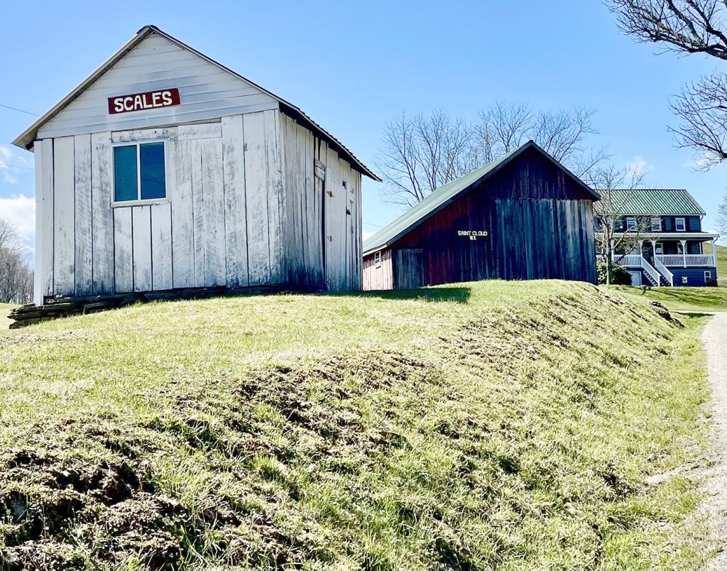 But Round Bottom Road, the last right hand turn before the state line, is an adventure waiting to happen. It winds through some nice “round bottom” fields and pastures attached to working farms, then climbs a mountainous hill to Honsocker Knob, 1652 feet in elevation. What remains of the town of St. Cloud is perched at the intersection of Round Bottom and Church Fork roads. The only house remaining has St. Cloud painted on its barn. This is where farmers brought their stock to be weighed and sold, Jim tells me. The stock sheds that once lined the narrow edge of the road are gone but the Scales shed in front of the barn is a landmark. The enjoined road now has two names here on the ridge – Brushy Fork Road according to the Department of Highways, White Creek Road according to those who live here. Never mind which name, the narrow strip of macadam waltzes with the ridge to Oak Forest Church, closed but certainly not forgotten. Families that have deep roots here tend to the church and its cemetery. Which includes Jim, who moved next door to the church some twenty years ago and feels he’s lived here long enough to have his plot picked out, he says with a grin. The map he gave me was copied from an old regional roadmap that he marked to show these points of interest. In a land of no Internet, not even on Honsocker Knob, it is my Indiana Jones connection to a lost world.
These steep hills were once a patchwork of hardscrabble farms and cross road villages but jobs that paid good money were elsewhere. Some homes remain in the high lands but not many. Between them are miles of hillsides and hilltops gone back to nature. Much of this is now owned by CONSOL but Jim says that plans to open Mason Dixon Mine never materialized as gas extraction became more profitable. Here on the ridge that leads into Pennsylvania in a few short miles, the only sign of corporate activity is a side road that hosts the entrance to the CNX Wadestown Deny Station.
The stillness of the trees and the conversation of crows is the background sound as spring begins to show but it won’t be long before the weekend motorcycles and four wheelers return to ride these forgotten roads.
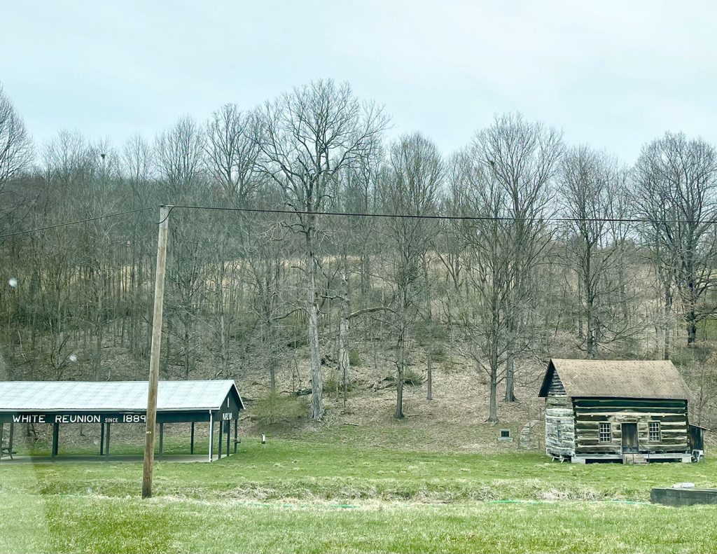 When Brushy Run waves goodbye at the end of the ridge and White Creek Road drops into fertile lowlands before slipping across the Pennsylvania line, it’s evident that the White family had the right to have a road named after them. A well-preserved log cabin sits beside a big pavilion sporting white letters visible from the road: “White Reunion Since 1889.” When the road finally connects to Gilmore Township to become SR 3006, or Hero Road, the county map in the glove compartment can come out. The forgotten village of Hero is just up the road, with an impressive historic sign that reminds travellers that it has a story to tell.
Priv. Jesse Taylor of Company F, 7th Regiment W. Va. Volunteer Infantry was “21 years one month” when he died at Romney, WV on October 26, 1861. He was brought home to rest in the cemetery on the family farm. Grandfather John Taylor Sr., a Revolutionary War soldier, purchased the land in 1806 and called it Hubely’s Delight. The village that grew up along the road and the road itself was named Hero after the war in honor of Jesse, brother Thomas, and brother in law John T. Pogue who all served in Company F.
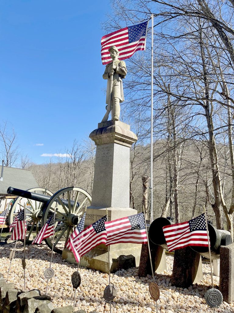 Family descendants restored Taylor cemetery in 1999, replacing gravestones and readying family history for display. By 2014 this impressive signage was in place, with a picnic table beside it for passersby. In a mile or so Hero Road joins with Jollytown Road that takes us into town. This is where fellow Civil War comrades S.W. Gilmore, G.W. Shough, Jefferson Dye, J.L. Garrison and W.H. Meighen erected the Jesse Taylor monument in 1892. The statue is surrounded by a crown of stones and flanked by two mortars and Hooser’s Battery – a West Point cannon used to defend New York harbor during the Civil War.
Hooser’s Battery has its own almost forgotten story to tell. After the war it was purchased for political rallies, then mysteriously abandoned in Greene County. Later it was rescued from a junkyard by veterans, re-abandoned, then saved by Colonel Charles I Faddis and brought to Jollytown to stand guard with Jesse.
By Memorial Day there will be fresh flags on veterans’ graves in every church cemetery, like those fluttering in the breeze around the Jesse Taylor monument. Pick up a copy of the Greene County map at Tourism if you don’t have one already and get out there. Pay attention to the numbers on the state road signs as their names change to reflect time itself as they pass through villages that might or might not still be there and follow creeks named after the first settlers who cleared the land.
May is also the time for nature lovers to hit the road – the annual Enlow Fork Wildflower Walk in State Game Lands 302 is May 1. So grab your map and leave early – guided tours begin at 10 a.m. Nebo Ridge Road aka SR 4008 in Richhill Township intersects with Route 21 near Wind Ridge then leads past the almost disappeared village of Nebo. There, the dotted lines of Walker Hill Road and Smokey Row will take you into Enlow Valley and the big creek that separates Greene and Washington counties. Prepare to be amazed at the carpets and clusters of Blue Eyed Mary, trillium, wild geranium, larkspur, Virginia bluebells and so much more, blooming along the banks of Enlow Creek. Which, by the way, is stocked for trout season. See you there!


