1876 was the centennial anniversary of the Declaration of Independence and the founding of the nation. A historic time indeed, one where Americans were looking not only to preserve their revolutionary past, but to create a record of their life and times in that centennial year. As such, all throughout the country, publishers and lithographers set out to make atlases of many of the counties then existent within the United States.
Greene County was no exception to this. In 1876, J. A. Caldwell, of Condit, Ohio published Caldwell’s Illustrated Historical Centennial Atlas of Greene County Pennsylvania. Caldwell created many centennial atlases for several counties in the region, but the Greene County atlas is perhaps the most stunning example. The atlas contains maps of each township and many of the more significant towns, illustrations of farms and businesses, and business directories, not to mention a section on the history of Greene County annexed with the text of the Constitution of Pennsylvania.
Unlike atlases from other counties however, the illustrations in the Greene County atlas were watercolored, giving them a wonderful folk-art quality.
Caldwell’s atlas provides us with an incredible snapshot of what life was like in Greene County in 1876, with views of farms that showcase livestock and capabilities. Coupling the illustrations with the information in the business directory, you can get an accurate look into life in rural southwestern Pennsylvania nearly a century and a half ago.
Farms of all size and capabilities were featured as illustrations in Caldwell’s atlas, from small plots of land with a simple farmhouse to grand late Victorian houses surrounded by rolling hills cultivated for various purposes. Many of these homes still stand today looking much as they did in 1876.
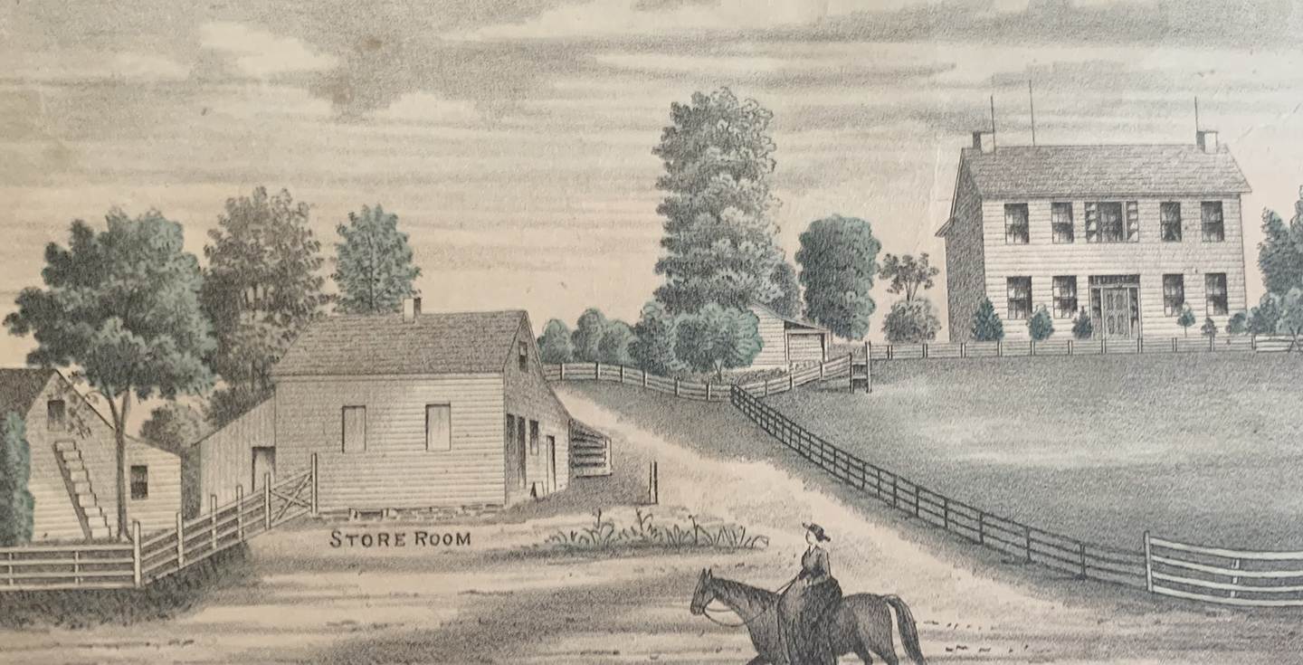
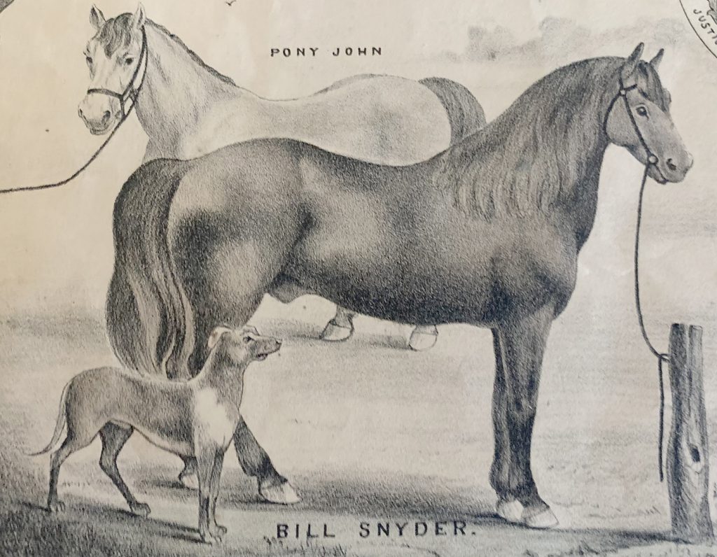 On page 26 of the atlas, viewers are greeted with a full page dedicated to the farm of Andrew Lantz in Greene Township, just a short distance west of Garards Fort. The page depicts his barns, two of his horses named “Pony John” and “Bill Snyder” as well as his Durham cattle, Poland hogs and Leicester sheep. Andrew’s 220-acre farm seems to have been quite successful, but little else can be learned about it from Caldwell’s atlas. Lantz is surprisingly missing from the business directory. The farm of William Kent in Wayne Township provides us with additional information.
On page 75 of the atlas, we see a beautiful image of Kent’s Georgian Revival home with its outbuildings, and an illustration of his mill. The business directory shares that Kent owned 280 acres of land and settled (or, in his case, was born) in Greene County in 1806. We also learn that he has a flock of 180 Merino sheep and that he is a “Farmer and Miller, constantly on hand, good supply of Flour, Corn Meal, Feed of All Kinds, Mill on Dunkard Creek.”
In this instance, we are lucky enough to know a little more about William Kent. William was born on Smith Creek, just a few miles south of Waynesburg to Thomas Kent Jr. and his wife Olive Smith. Thomas Kent Jr. was a son of Revolutionary War patriot and Greene County pioneer Thomas Kent. William Kent lived on Smith Creek until 1855, where he also operated a mill. He later purchased land in Wayne Township where he would build his new home and mill, having saved and transported the mill stones from his mill on Smith Creek to his new mill on Dunkard.
William Kent was married to Elizabeth Odenbaugh in 1829, and the couple would raise eleven children. Elizabeth died in 1868, and William would later remarry Jane White, the widow of Michael White. William would live on his farm until his death in 1888.
Also on page 75 of Caldwells atlas, just above the Illustrations of William Kent’s home and mill, we see a view of Richard Moffett’s Cumberland Township home and farm that shows his sheep and cattle, as well as an image of the residence of Z. G. White in Oak Forest, a smaller farm but one that raised thoroughbred Yorkshire pigs and Merino sheep. We are also greeted by a view of the Blair and Moffett Store, owned by Jesse Blair of Oak Forest who was a dealer in groceries, dry goods, ready-made clothing, hats, caps, boots, and shoes.
 Notably on the Franklin Township map, a few miles east of Waynesburg the County Home is annotated. Very little information is given; however, it shows an icon representing a building and it designates an orchard and states that the property contains 147 acres. This is of course the site of the former Poor Farm, now the Greene County Historical Society.
The maps can be very useful in this respect; they generally designate orchards, family cemeteries, schoolhouses, mills, agricultural buildings, and areas designated for specific agricultural or industrial practices.
In 1876, Greene County Pennsylvania was just beginning to experience the effects of the Industrial Revolution and was still largely an agricultural community. The 1876 Caldwell’s Atlas captures a snapshot of Greene County before industry began to take over. Within the next 50 years the county would see huge advances in oil and gas that would begin to dominate the local economy. Agriculture would fall to the side lines.
The illustrations in Caldwell’s Atlas are stunning. Many first editions of the atlas have been broken down and cut apart with the illustrations and maps framed individually to be displayed in homes and businesses, but others have survived complete. Cornerstone Genealogical Society sells reprints of the 1876 atlas, and first editions can be viewed at the Greene County Historical Society.


