The Greene County area’s bucolic hills and peaceful woodlands make it the perfect place to get out and enjoy the outdoors. The area boasts multiple trails for enjoying nature and avoiding the crowds.
Greene River Trail
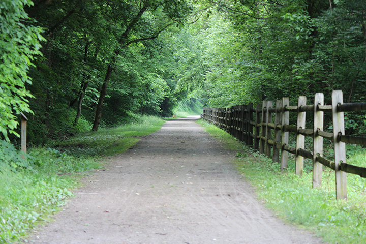
 This 5.2-mile trail, with additional 2.2 miles under construction, follows the winding path of the Monongahela River. It is ideal for walking, running and biking. The trail offers scenic views of the Monongahela River and surrounding wooded areas. The trail begins at Greene Cove in Jefferson Township and ends at the former Crucible Ferry landing. Parking is available at the Greene Cove Yacht Club and Rices Landing Borough, across from Pumpkin Run Park.
The trail travels past several of the county’s coal communities. The Rices Landing Historic District can be viewed from the trail, including locations such as the W.A. Young & Sons Foundry & Machine Shop in Rices Landing. The shop provided machine parts for steamboats and mine machinery, making its location along the Monongahela very convenient. The river served as a water highway for the coal industry and played an enormous part in establishing the economy of our region. Nearby in Rices Landing, a gazebo and Pumpkin Run, Kolat and Min- Love parks are an enjoyable stop. Please contact the Department of Parks & Recreation for more information.
Warrior Trail
 Scholars of the Warrior Trail calculate that Native Americans used it for over 5,000 years for trade, hunting, and warfare. A large section of the trail’s 67-mile length passes through Greene County. The 45-mile Greene County segment begins in Greensboro and ends at Pennsylvania’s border with West Virginia, six miles north of the Mason-Dixon Line.
As it winds through the county, the Warrior Trail passes through the towns of Aleppo, Nettle Hill, and Kirby. It follows a stream divide that separates the watersheds of Whitely and Dunkard Creeks. The trail is marked by conspicuous yellow dots on trees and posts, as well as both sides of any road crossing. The trail can be entered at any of its intersections with a nearby road. Tour guides are available by contacting the Warrior Trail Association. These guides will point out local and historical points of interest along the trail. Large portions of the trail pass through private property, so trail users must respect the rights of property owners. The trail is voluntarily maintained through the Warrior Trail Association and local service groups.
Waynesburg Unity Trail
The Waynesburg Unity Trail is approximately 2 square miles, including 1.5 miles of walking trails and wooded areas that are preserved for student research and environmental restoration. The trail is a safe place for students to learn and do research while spending time with nature. The trail is also available to the greater Waynesburg community to enjoy and appreciate nature in an urban setting.
Parking is available on East Wayne Street or at the bottom of Martin Hall on East Franklin Street. Access to the trail is at the top of the hill by Martin Hall. There are public bathrooms in the Stover Building at the top of the hill.
Ryerson Station State Park
 Eleven miles of trails wind their way through this Ryerson Station State Park in Wind Ridge. Hikers are able to witness a large number of different habitats, from open fields and mature forests, to marshy valleys and evergreen plantations. Trek these paths on-foot throughout the spring, summer, and fall—or strap on your cross-country skis for a winter hike. The park offers over two hundred picnic tables for hungry visitors to stop for lunch. There is also a playground and public pool located at the park, and pavilions are available for rental and everyday use. Ryerson also has restrooms for public use, as well as campgrounds for both tents and trailers.
Browns Run Trail
 Browns Run Trail currently follows the abandoned Monongahela Railroad line from the mouth of Browns Run on the Monongahela River to State Route 21 near Masontown. At this time, the trail extends 7/10ths of a mile from the Wilson-Lardin Mansion to the vicinity of the Rabb House near Ronco-Gates Road. Along the trail there are 4 footbridges, benches along the path, and the surface of the trail is made of pressed stone. A proposed continuation on the trail will eventually pass through the heart of coal and coke country in Fayette County, hopefully becoming a part of the Sheepskin Trail and covering approximately 12 miles.
Sheepskin Trail
 The West Virginia to Point Marion section of the Sheepskin Trail is 1.7 miles long and starts at the West Virginia/Pennsylvania border where it connects with the Mon River Trail. From the border, it travels north along the Monongahela River, through the heart of Point Marion, and ends at the 119 bridge that crosses the Cheat River. The trail will eventually extend 34 miles and connect Point Marion to Dunbar.
Friendship Hill

The Friendship National Historic site is located north of Point Marion and includes 9.6 miles of trails of varying distance and difficulty. The trails forms loops around the site and wader through meadows and woodlands. The trails are located near the historic home of Albert Gallatin, now converted into a museum with exhibits. Programs are available throughout the year that focus on both history and nature. There is a picnic area and a comfort station located near the parking area.
Greensboro Borough Trail
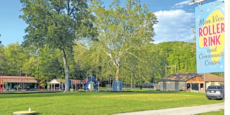
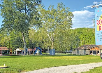
Greensboro is an historic pottery-manufacturing town adjacent the Monongahela River. This 1.5 mile of bituminous and concrete paved hiking and biking trail extends from Greene County’s Mon View Park through Greensboro Borough to the historic Lock Master’s house. Mon View Park includes a large playground, pavilions, pool, and a skating rink. Nearby are a concrete historic walking trail with amenities such as steel benches and bicycle racks; a large 50’ hexagonal steel gazebo shares the area.


